Underground utilities are essential components of modern urban infrastructure, silently delivering vital services like water, gas, electricity, and communication. Despite their invisibility, these utilities play a crucial role in maintaining the efficiency and comfort of our cities.
However, the very fact that these utilities are hidden beneath our feet poses significant risks and dangers. Accidental damage to underground utilities during construction, excavation, or maintenance activities can lead to severe consequences.
Understanding underground utilities
Underground utilities refer to the intricate network of pipes, cables, and conduits hidden beneath the surface of the ground. These utilities serve as the silent backbone of urban infrastructure, delivering essential resources and services to homes, businesses, and industries. While often unseen, underground utilities play a vital role in ensuring the functionality and livability of modern cities.
Types of underground utilities:
- Water supply lines
- Gas pipelines
- Electrical cables
- Telecommunications networks
- Sewage systems
The risks and dangers of underground utilities
Accidental damage to underground utilities can lead to a cascade of adverse consequences, impacting various aspects of urban life and infrastructure.
- Service disruptions: Damage to underground utilities can disrupt essential services such as water supply, electricity, gas, telecommunications, sewage, and stormwater drainage. This can cause inconvenience to residents, businesses, and public facilities, affecting daily activities and operations.
- Financial losses: Repairing damaged underground utilities often requires significant resources, including labor, materials, and equipment. Additionally, service disruptions may result in financial losses for businesses and organizations due to downtime, reduced productivity, and potential revenue loss.
- Safety hazards: Accidental damage to underground utilities poses safety hazards to workers, residents, and the general public. For example, ruptured gas pipelines can lead to explosions or fires, while severed electrical cables can cause electrocution risks. Water pipe breaks can result in flooding and water contamination, posing health and safety risks.
- Environmental damage: Damage to underground utilities can also have environmental consequences. Leaks or spills from sewage systems or chemical pipelines can contaminate soil and water sources, leading to environmental pollution and ecosystem damage. Additionally, stormwater drainage system failures can result in flooding and erosion, impacting natural habitats and landscapes.
Challenges of managing and maintaining underground utilities:
Managing and maintaining underground utilities present several challenges, primarily due to their hidden nature and complexity.
- Limited visibility: Unlike above-ground infrastructure, underground utilities are hidden from view, making it challenging to accurately locate and assess their condition. This limited visibility increases the risk of accidental damage during construction, excavation, or maintenance activities.
- Regulatory compliance: Compliance with safety and environmental regulations adds another layer of complexity to managing underground utilities. Meeting regulatory requirements necessitates meticulous planning, documentation, and execution, further complicating the management process.
- Technological limitations: Traditional methods of utility detection and mapping may have limitations in terms of accuracy and efficiency. This can hinder effective management and maintenance practices, leading to increased risks and challenges.
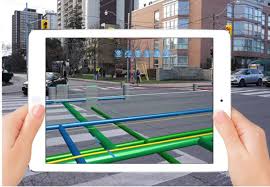
The need for underground utility mapping software
In urban infrastructure management, accurate mapping plays a pivotal role in mitigating risks associated with underground utilities, ensuring safety, efficiency, and cost-effectiveness in construction, excavation, and maintenance projects.
The precise location of underground utilities must be recorded with the help of a technological solution that employs modern underground mapping techniques like GPS, GPR, and EM. Accurate underground utility detection software solutions provide detailed information about the exact position, depth, and type of underground utilities, enabling project stakeholders to plan and execute their tasks with precision. By knowing the precise location of utilities, construction crews can avoid accidental damage during excavation, minimizing the risk of service disruptions, safety hazards, and financial losses.
Additionally, accurate documentation helps streamline communication among project teams, regulatory authorities, and utility providers, enhancing collaboration and minimizing potential conflicts.
Key features of effective underground utilities mapping solutions
Accurate data collection
Precise data collection is crucial for underground utility mapping solutions as it provides detailed information about the location, depth, and type of utilities. Accurate data allows project stakeholders to plan construction activities more effectively, minimizing the risk of accidental damage to underground infrastructure. By ensuring that utility locations are precisely mapped, accurate data collection enhances safety, efficiency, and project outcomes.
Real-time data sharing
Real-time data sharing capabilities enable seamless collaboration among project teams, stakeholders, and utility providers. By sharing up-to-date information about underground utilities in real time, mapping solutions facilitate better decision-making and coordination, reducing the likelihood of conflicts and delays. Real-time data sharing enhances transparency and accountability, fostering a more efficient and collaborative project environment.
User-friendly interface
An intuitive user interface is essential for underground utilities mapping solutions to ensure ease of use and accessibility for all stakeholders. A user-friendly interface simplifies the process of accessing and interpreting utility data, allowing project teams to navigate the mapping software with ease. By providing a seamless user experience, an intuitive interface enhances productivity and encourages widespread adoption of mapping technology across project teams.
Regulatory compliance
Ensuring compliance with safety and environmental regulations is a fundamental aspect of underground utility mapping solutions. Mapping software plays a crucial role in facilitating regulatory compliance by providing tools and features to document and manage underground infrastructure according to regulatory requirements. By helping project teams adhere to safety and environmental standards, mapping solutions minimize the risk of legal liabilities and ensure the sustainable development of urban infrastructure.
Why PointMan is the ideal underground utility mapping software
PointMan excels in providing accurate data collection, enabling precise mapping of utility locations, depths, and types. It employs modern underground mapping techniques that let you capture, record, and visualize precise utility data. Its real-time data sharing capabilities foster collaboration and informed decision-making among project stakeholders. Additionally, PointMan boasts a user-friendly interface, ensuring ease of use and accessibility for all users. Its compliance tools facilitate adherence to safety and environmental regulations, reducing legal liabilities and ensuring sustainable development practices.
PointMan stands out as the ideal underground utility mapping software due to its comprehensive suite of features designed to address the unique challenges of managing underground infrastructure. By offering accurate data collection, real-time sharing, user-friendly interface, and regulatory compliance tools, PointMan empowers project teams to navigate the complexities of underground utilities safely and efficiently. Its advanced capabilities enhance safety, streamline project execution, and minimize the risk of utility damage, ultimately contributing to the success of urban infrastructure projects.
In conclusion, PointMan sets the standard for underground utility mapping software, providing the tools and resources needed to ensure the smooth and effective management of underground infrastructure projects. With PointMan, project teams can confidently navigate the hidden challenges of underground utilities, leading to safer, more efficient, and ultimately successful outcomes.
Write and Win: Participate in Creative writing Contest & International Essay Contest and win fabulous prizes.